Results All Pictures on Google Photos
In the news: Vallée de Joux , Le Nord Vaudois
Here a recap of my experience
1st day
Task: Baulmes - Suchet - Mont Aubert - La Grand Vy (Creux du Van) + optional turn points further in the east
Weather: Strong winds were present at higher levels with about 50 km/h west. However, in the morning close to the ground it was still OK and has been announced to reinforce only for the afternoon, that could disable any take off.
Thus, it was important to get quite fast to the first turn point, the Suchet, to be able to take off in good conditions. I managed to hike up in a decent time and took off in direction of Mauborget. The air was quite bumpy, thermals small and deviated by the wind. Got well to Mauborget with a down point after Vuitbeouf. Then, I took to much risk and went very low (after the power cable) in direction of the Mont Aubert, I just counted on thermals that are usually present, but no, not that time... So I landed on the slope in direction the Mont Aubert and watched my friends flying over me :-( . Walked up together with Luca an Italian, to the turn point and took a nice break at the restaurant on the Mont Aubert, cheering up with Marc and Pierre.
Without any further safe take off place we walked to the goal (Ok José took off on the small view point on the Mont Aubert = turn point, but that's definitely not for my nerves) .On the way we crossed our bus stuck in the snow. He managed finally only with the help of a tractor to get out of his situation.
Some competitors, who managed passing the Mont Aubert by flying, tried to reach one turn point further east (Rocher Les Tablettes). But for many it turned out as too challenging: not far from the final goal but with a deep gorge in between (approximately +700m on both side hiking - and much too strong winds for take offs). Just endurance cracks got back on time (or within 15' delay limiting severe penalties): Fabian Umbrich, Sylvain Freiholz, Alexandre Lamon, Laurent Borella, Christian Court and Steven Bramfitt.
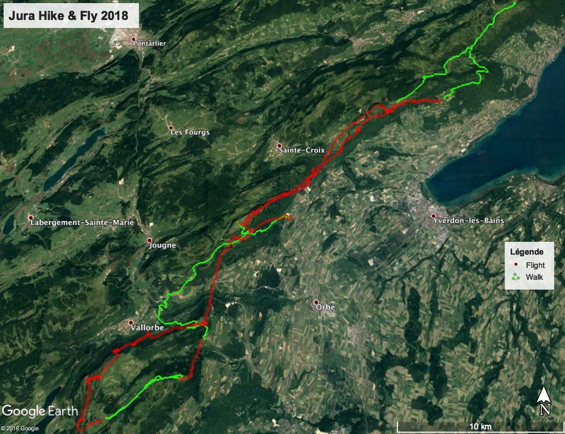
Hiking: 21 km +1700 m Baulmes-Suchet, Fontenazier-La Grand Vy
Flying: 18 km Flight Suchet - Fontenazier

2nd day
Task: La Grand Vy - Mauborget - Antennes Premiers - La Breguettaz (opt: Chasseron, Dent de Vaulien, Morand, Chatel, Chalet Devant, ..)
Weather: Humide in the morning. Low levels east to south wind. Further in the ouest - ouest winds (in the Alps weak Foehn is building up). Nice cumulus for noon.
2 tactics to start: either a short flight from the Roche devant in direction Mauborget or direct walking without big level difference to Mauborget. I choosed walking and arrived with Noé and Cricrou in about the same time as the the flying/walking folks in Mauborget.
Flying to the Suchet was quite OK, but arriving there I saw many struggling at lower level. I managed to get a nice thermal and this also just after the Mathoulaz, reaching nearly 1700m. With this height I crossed directly the valley flying over Lingerolle. Ahead of me I saw on the ridge further the "Antenne Le Premier" 1 Glider (Steven on a LM) and behind me followed José on his Klimber. I arrived on the level of the Restaurant Combaz and soared up on the south tree ridge passing the turn point. Then I deviated to the north side of the ridge (thought eventually to land to validate the walking turn point Fort Giroud) and catched a nice thermal to climb up again the ridge in direction Dent de Vaulion. On the south -east side of the Dent the Vaulion I found myself very low at the last row of tree (Auberge du Morez) but found in last call the saving thermal to reach the Turn Point. At 1600 m I headed direction Chatel, where I spotted Steven, however I faced strong headwind and was just attracted by the final goal to take a break. José headed on in direction Chatel, making the final approach by hiking. After 2 hours break and a nice meal at the Breguettaz, I decided to validate another turn point, Chalet Devant 5 km away.
Hiking: 27 km +500 m Grand Vy - Mauborget, La Breguettaz - Chalet Devant - La Breguettaz
Flying: 32 km Mauborget - La Breguettaz
3rd day
Task: La Breguettaz - Chalet Devant - La Mathoulaz - Baulmes (opt: Antenne Premier, Le Cochet, ...)
Weather: South wind (Foehn in the Alps)
Hiking as everybody to the Chalet Devant and taking off in direction Premier. Landed in Premier and walked up to the antenna. At the Auberge des Auges I tried to take off twice as many others, but without luck (very flat slope - so only chance to pass the trees is when you get a lift by the wind...). Thus walked over Ballaigues, ok perhaps not the shortest track but a nice one, to La Mathoulaz for a final take off.
Hiking: 24 km +1100 m La Breguettaz - Chalet Devant Premier-Antenne Auges-La Mathoulaz
Flying: 6 km Chalet Devant - Premier La Mathoulaz - Baulmes

Total: Hiking 72 km +3300 m , Flying 56 km


